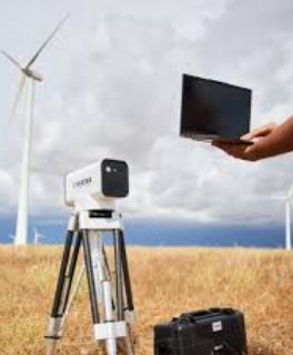
The Role of LiDAR Sensors in Modern Technology
In recent years, LiDAR (Light Detection and Ranging) sensors have become one of the most innovative and powerful tools in various industries. LiDAR technology uses laser light to measure distances and create high-resolution, three-dimensional maps of environments. With its ability to provide detailed and accurate spatial data, LiDAR has found applications in fields such as autonomous vehicles, environmental monitoring, agriculture, and urban planning. This article explores the functionality of lidar sensor, their benefits, and their diverse applications.
What is a LiDAR Sensor?
A lidar sensor is a device that emits laser pulses and measures the time it takes for the light to bounce back from the target object. The sensor then calculates the distance between the sensor and the object based on this time delay. By emitting millions of laser pulses per second, LiDAR systems can generate highly accurate 3D data points that represent the physical characteristics of the environment.
LiDAR sensors come in different forms, including airborne systems mounted on aircraft or drones, terrestrial systems used on the ground, and mobile systems attached to vehicles. These systems use a combination of laser scanners, GPS, and inertial measurement units (IMUs) to provide precise spatial information, which can be further processed into detailed digital models.
Benefits of LiDAR Sensors
1. High Precision and Accuracy: One of the key advantages of LiDAR technology is its ability to capture extremely accurate measurements, even in complex and challenging environments. LiDAR sensors can measure distances with millimeter-level precision, making them invaluable for applications that require high levels of detail, such as topographic mapping and construction site surveying.
2. 3D Mapping Capabilities: Unlike traditional sensors that provide 2D data, LiDAR creates three-dimensional representations of the environment. This 3D capability enables better visualization and analysis of terrain, objects, and structures, providing a more comprehensive understanding of the physical world.
3. Speed and Efficiency: LiDAR sensors can collect vast amounts of data in a short amount of time. This makes them ideal for applications that require rapid data collection over large areas, such as environmental monitoring, forestry, and infrastructure inspections. The speed of LiDAR data collection also reduces fieldwork time and operational costs.
4. All-Weather Operation: LiDAR sensors are highly effective in various weather conditions, including fog, rain, and darkness. Unlike cameras or radar systems, which can be affected by poor visibility, LiDAR’s laser pulses can penetrate these environmental challenges, making it a reliable tool for all-weather operations.
5. Non-Contact Measurement: Since LiDAR uses laser light to collect data, it is a non-invasive, contact-free technology. This feature makes it suitable for measuring delicate or hazardous environments without causing any damage or risk to the sensor or the target object.
Applications of LiDAR Sensors
1. Autonomous Vehicles: LiDAR plays a crucial role in the development of self-driving cars. It helps vehicles detect and map their surroundings by providing real-time 3D data about obstacles, road conditions, and other objects. LiDAR sensors work alongside cameras, radar, and other sensors to enable safe navigation and decision-making for autonomous vehicles.
2. Environmental Monitoring: LiDAR is widely used in environmental studies, particularly for mapping forests, wetlands, and coastal areas. It helps scientists monitor changes in vegetation, soil erosion, and land degradation, providing valuable insights for conservation efforts and land management.
3. Agriculture: In precision agriculture, LiDAR is used to create detailed maps of agricultural fields, helping farmers optimize irrigation, fertilization, and crop management. The ability to assess the topography and condition of the land aids in making informed decisions about planting and harvesting.
4. Urban Planning and Infrastructure: LiDAR technology is often used in urban planning to create 3D models of cities and buildings. These models are invaluable for designing infrastructure, assessing the impact of new constructions, and planning urban development. LiDAR can also be used for monitoring the condition of bridges, roads, and other critical infrastructure.
5. Archaeology and Heritage Preservation: LiDAR has proven to be an essential tool for archaeologists in mapping ancient sites and structures. By scanning large areas of land, LiDAR can uncover hidden features, such as buried ruins or ancient roads, without disturbing the site. This non-invasive approach preserves the integrity of historical landmarks while providing valuable data for research.
Conclusion
LiDAR sensors are transforming industries by providing high-resolution, accurate, and efficient 3D data collection capabilities. Their applications are diverse, ranging from autonomous vehicles to environmental monitoring, agriculture, and urban planning. As technology continues to evolve, LiDAR is expected to play an even greater role in shaping the future of industries that rely on precise spatial data. With its ability to capture complex and detailed information quickly and accurately, LiDAR is a game-changer in modern technology, offering endless possibilities for innovation and progress.
Proudly powered by WordPress. Theme by Infigo Software.